Black Bear Pass
August 4 - 6


After driving 1950 miles / 3138 km across America in 45 hours, almost non-stop, we reached our first night location. We spent that night by the Monarch River in Colorado, at an altitude of 2,710 m / 8,891 ft. Our following day's destination were the San Juan Mountains. Travelling on highway 550, we stopped in Ouray. This is a village founded by miners that crazed over silver and gold that is located in a deep valley. The location is fantastic. Ouray to this day retains some of the iconic western atmosphere, mainly due to the architecture from the era of the first settlers.


We did not stay in Ouray for long. Driving farther, we turned off highway 550 and onto dirt road. Ahead of us was a mountain passage commonly known among off-road enthusiasts. Its name is mentioned with dignity and respect. Black Bear Pass Road is widely considered one of the most dangerous roads in Colorado and even in the whole United States. For what reason is traveling on this road more dangerous than other mountain roads? - I asked myself. It was obvious that it is a scenic drive through the mountains and that the road is only open in the summer for two months. From this information, I did not expect anything dramatically surprising.

The winding dirt road took us up to a great alpine valley. The surrounding peaks were well over 4200 m / 13,000 ft. in altitude. Not only landscape changed, but also the weather. The coming storm looked grim. It was starting to rain and the clouds turned an ominous black color. We stopped to have lunch, but were unable to sit or rest due to the oncoming rain. In a hurry, we packed up everything when the cold wind and rain became unbearable.


Aboard the Jeep, we continued to climb, but this time a shorter distance and less steep of a road. We finally got to the highest point on the Black Bear Pass, 3,914 m/ 12,840 ft. above sea level. It was a record for highest altitude driven by Balios so far. In contrast to us, he had no breathing problems even with less oxygen in the air at high altitude. His engine sounded normal and happy, only we gasped after walking only a few steps.

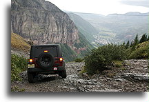
From this point on the descent began, initially nice and easy. The drizzle started for good. The dirt road was covered with rocks that turned into a muddy, smooth, and shiny glass-like surface. It felt like driving on ice. After a few steep downhill passages, I stopped to check the condition of the road in front of me. The blood ran cold in my veins. Balios was now where a nearby stream turned into the Ingram Falls. The route was on the edge of the waterfall's cliff on one side and a high slope on the other. The road was covered by loose shale and inclined toward the waterfall. Because of the falling rain the dirt road was also covered with muddy streams of water. I had no doubt that when the brakes would lock my Jeep would slide like a sleigh in winter. Any object that will get momentum at this point and loses traction will drop twenty yards at the best, by doing the spectacular waterfall jump. Seeing all of this, I walked down the slope and accurately analyzed it. I started to consider the possibility of staying in a tent overnight in the mountains, waiting for the weather to improve. Dry road would ensure a better grip. However, for how long would we need to wait? It can rain in the mountains for days. Turning back and returning the way we arrived was not an option. There were similar slippery sections, some climbs difficult in the rain.


This part of Black Bear Pass, near Ingram Falls, is often called the steps. In order to plan my route, I walked three times up and down the slope on foot. The most important part was to keep to the right side, away from the edge of the road on the left and at the same time not bump into the slope. I decided that we had to take this challenge; I turned the ignition and Balios came back to life.


Balios was moving slowly. The low range gear (4 low) was on. I was pressing the brake and could feel the car was on the verge of locking its brakes and slipping. On wet slick boulders on the ground the tires began to slip, until they found a piece of mud with more traction. Then, the vehicle was rolling again. Stay away from the edge I was repeating myself constantly. Loose rocks jumped out from under the tires. The waterfall thundered loudly in the immediate vicinity. I did not have time nor did I want to look in that direction. All I wanted was to get to the place where the rock steps ended and I could stop safely.


The worst seemed to be over. In front of us stretched a truly phenomenal view. 1000 meters / 3500 feet below we could see Telluride nested in the valley. The road ahead of us led down a vertical cliff with numerous switchbacks. Some curves here were so sharp that we needed to overcome them in two or three tries, going forward a little and backing up. At the same time, we needed to make sure that the edge of the road was at a safe distance from the front wheels.


After reaching the valley floor, we found ourselves in the mountain resort of Telluride. The weather was awful. The thought of breaking down the tent in the rain and frigid temperature aroused disgust in all of us. We decided to continue the journey to the not so distant Mesa Verde, where just as could be predicted the land would be arid and hot.

